Spokane to Aspen
Fall 2018
Denis Kertz, ©2018
Sat, Sep 01, 2018 - Naperville, IL
This
year’s bicycle tour’s highlight is a family visit. It starts in Spokane, WA, passes through
Boise, ID, and ends near Aspen, CO. I have
nephews and nieces in these 3 locations.
The first location, Spokane, is convenient because the Amtrak Empire
Builder train has a stop in Spokane so it is easy to get my bicycle to my start
via the train. This Amtrak Empire
Builder train is the same one I took last year when I got off at East Glacier,
MT. This year is only different in that
I stay on the train a little longer before getting off in Spokane,
The
other convenience about the train is that I can handle all the travel by
myself. I live 1.5 miles from the
commuter train station in Naperville that takes me to Chicago Union Station for
the Amtrak train. A limited number of
bicycles are allowed on the commuter train during the week outside of rush hour
and any time on the weekend.
On
the weekend, the train is available hourly at 8:33, 9:33, etc. The Amtrak train leaves at 2:15 pm so there
is plenty of time to get to Union Station.
However, bicycles occupy the space reserved for handicapped devices and
handicapped devices have priority and you never know how many bicycles might
show up for a train. So I was planning
to take the 9:33 train which left a couple more trains as options if necessary.
This
Saturday was forecasted for heavy rain in the morning. That made me decide to take an earlier train
to avoid having to ride to the station in the rain. When I was thinking about leaving for the
station around 7:30 it started raining heavily.
However, it stopped raining for a while just after 8 so I rode to the
station at that time and caught the 8:33 train.
One
issue with getting a loaded bicycle on the commuter train is that you have to
lift it up several steps. When the train
arrived I watched for the handicapped car which was at the front of the train. I was dismayed when the handicapped car was
past the platform - I didn’t know how I would be able to get the bike on the
train. However, the conductor called to
me and pointed to a second handicapped car that was by the platform. Still, it was a job to lift the bicycle up 3
steps from the platform. The conductor
helped out by lifting the rear of the bicycle.
Since
this commuter train stopped at every station along the way, it took a little
more than an hour to reach Chicago Union Station. Then I had to kill over 4 hours waiting for
the Amtrak.
Last
year was the first year I was able to just hand Amtrak my bicycle for them to
put in the baggage compartment. In
previous years I always had to box it up in an Amtrak box. What was especially nice last year we (myself
and another cyclist) were asked to walk our bicycles first to the baggage
compartment but not this year. I was
expecting the same this year but when it was obvious that wasn’t going to
happen I asked the station attendant and he motioned for me to bring my bicycle
up front. Eventually I rolled my loaded
bicycle to the baggage compartment. It
seemed like the baggage guy was prepared to take my loaded bicycle (but I’m not
sure he was aware how much it weighed) but I removed my 4 panniers and the
duffel bag where I had my sleeping bag and tent. I carried them on the train, carrying the 2
smaller front panniers to my seat, putting one overhead and the other under my
seat.
Luckily
the train was not that full and I had a 2-seat row to myself. That made sleeping much easier by allowing me
to stretch across the 2 seats. As usual
I didn’t sleep great but I got a reasonable amount of sleep.
The
big question with Amtrak is always how close to on time it will it be. Since the freight trains own the tracks,
whenever there is a conflict with an oncoming train Amtrak loses and has to
pull off to the side to wait for the freight train to pass. The next morning was looking good as we had
an hour wait at Minot, ND, 30 minutes more than planned. However, we lost time after that and by the
time we reached East Glacier the train was a couple of hours behind. That meant the 1:40 am scheduled Spokane stop
was going to be later.
I
was also expecting that I would have a seat mate for my second night on the
train. Last year I got off at East Glacier
but there were a lot of folks waiting to get on. The conductor had told the other cyclist who
was going to Seattle that the train would be full so I was expecting the same
this year. Maybe last year was an
anomaly or maybe the difference was last year was Monday night and this year it
was Sunday night. In any event,
apparently only a few folks got on at East Glacier and I was able to get some
sleep before the Spokane exit.
I
went to sleep somewhere around 9 pm and by the time we stopped at Spokane the
train had made up about an hour of the 2-hour delay. I collected my panniers and duffel bag and
walked down to the baggage car where I was handed my bicycle. 15 minutes after getting off the train I was
packed and ready to ride.
Planning
for this trip I had an interesting decision to make - whether to get a motel
for the night or crash in the station.
Obviously, the later the train the less sense it made to waste a motel
night. On the other hand, my nephew had
warned that the train station wasn’t in a great part of town. I ended up emailing the Spokane police
department to solicit their advice about safety. I was warned that there was a homeless
population around the area and some of them could be aggressive. The police lieutenant who responded said he
wouldn’t advise staying in the station and if it were his decision he would get
a motel.
So
I made reservations at a Day’s Inn that was just a couple of blocks away. I had my lights ready and it was a quick ride
to the motel. When I made the
reservation I was careful to make sure I could check in at that time in the
morning. The reservationist suggested I
could make a special check-in so I wouldn’t have to worry about checking out at
the normal checkout time. That made
sense to me but when I checked in the attendant said there was a $20 early
check in fee and I complained that I was just quoted a $59.99 rate. As it turned out this $59.99 rate got me
checked in early and it was good until the next day’s normal checkout
time. So in effect I got a night and a
half room for the normal room rate - a good deal.
Mon, Sep 03, 2018 - Naperville, IL to Spokane, WA
Between
sleeping on the train and sleeping at the motel I got a reasonable night’s
sleep and the motel had a decent continental breakfast.
The
plan for the day was to visit my niece and nephew since I rarely get to see
them. Even better, my sister, Judy, was
in town and she turned out to be my personal chauffeur for the day. Later in the morning, she came by and picked
me up and drove me to my niece’s house where I met Isaac (6) and Abby (nearly
4) for the first time. Unfortunately,
Krissy’s husband, Matt, works for the fire department and was working so I was
unable to meet him.
Later,
we arranged to meet with my nephew’s family at an eating place, the Fieldhouse,
in Liberty Lake for lunch. There I met
my nephew, Dan, his wife, Steph, and their 2 sons, Logan (12) and Brant (10). It was a great lunch time since there weren’t
many others around.
After
lunch Judy took care of Isaac and Abby so Krissy could complete some errands
and we drove back to Dan’s place and visited on the deck for most of the
afternoon. Then Judy drove me back to
the Day’s Inn where I made some final preparations for the start of the tour in
the morning.
It
was a great day starting with a good end to the train ride and ending up in a
motel for 2 nights while paying for one night.
Then meeting up with my niece and nephew families with a personal
chauffeur was just right.
Day 1: Tue, Sep 04, 2018 - Spokane, WA to Coeur
d'Alene, ID [58.5, 6:03, 9.6 mph, +1,998', -1,724']
I
ate breakfast again at the Day’s Inn continental breakfast. This was better than yesterday because I
figured out they had sausage patties that yesterday I thought were
pancakes. They also had a scrambled egg
patty so I had a sausage and egg sandwich on a bagel. I also had a bowl of granola.
I
decided not to hurry leaving to give the rush hour traffic time to calm
down. I left about 8:45. Since the day’s route to Coeur d’Alene was
almost all on the Centennial Trail, all I had to do was ride about a mile to
get on the trail. I headed north on the one-way
Division Street. Since it was busy I
just rode on the sidewalk.
Every
trip has a problem and the only question was how soon would it happen. For this trip the answer was
immediately. I noticed right at the
start that my trip computer wasn’t working.
I have a wireless unit and I replaced both batteries before I left home
so I was sure a battery was not the problem.
I tried adjusting the spacing between the magnet on the wheel and the
transmitter but that didn’t work. I was
hoping there was some interference in the area that was messing up the signal.
I
kept riding north to the Spokane River where I would pick up the trail on the
south side of the river. I almost
crossed the river when I noticed the trail below the elevated street. So I stopped and made my way down to the
trail. Then I played around with my trip
computer again. Finally, I removed the
display unit from its holding unit and put it back again and it started working
again. Apparently the display unit lost
sync with the transmitter and replacing the display unit caused it to go
through the sync routine again. That was
a relief to have that out of the way.
The
trail was nice riding. It was paved with
a couple of short stretches that were on the street. I rode through part of the campus of
Washington State at Spokane and Gonzaga.
It
was 23 miles to the Idaho border, an easy ride on the flat, paved surface. I reached the Idaho border at 11:30 so I
thought it would be a short day since that was the half way point to Coeur
d’Alene.
Krissy
had warned me that the trail was convoluted around Post Falls and that was the
case. I thought they did a pretty good
job of signing the trail so I didn’t have any problem following the trail,
until I reached a T-intersection where the bicycle sign pointed in both
directions. I turned right and found out
that was the wrong way. So I turned
around I saw signs again for the trail.
I
crossed a major intersection and then rode on what looked like it could be the
trail but it dead-ended. So I turned
around and rode back. I asked a cyclist
at a light and he pointed to the major intersection to pick up the trail. When I got back to the major intersection, I
was confused until I saw the signature yellow wiggle line of the trail on the
pavement off to my left. I guess the
construction at the intersection must have hidden a sign or distracted me but I
got back on track.
That
got me into Coeur d’Alene where I ran into another issue. I followed trail signs that led to a U-turn
in the trail and I figured that couldn’t be right. After backtracking I finally pulled out my
cell phone and checked Maps.ME which showed the trail. It also showed that the U-turn was correct
since it was followed by another U-turn that got me riding along the lake
shore.
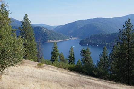
There
were good views along the lake shore and folks were out on the long beach
enjoying the day. The day had started
out with a low of 45. It was about
mid-50s when I started riding and it was in the 70s by early afternoon.
I
lost the trail again when it neared the city park but Maps.ME saved me again
and I got back on track. The trail led
me to where I picked up Sherman Ave.
There I was lucky enough to meet another guy riding a BMX bicycle and I
asked him about a grocery store. He knew
there was a Safeway and he googled it and showed me where it was, a little less
than a mile away.
I
did my first real food shopping since I expected to end up at a campground and
would need my own food. Maps.ME showed
me how to pick up the trail again when I left the grocery store. The trail led me to Lakeshore Drive with the
trail alongside the road. The problem,
however, was there was a big hill heading east and the trail could not get me
to the intersection of the Interstate and ID97 where my campground was.
I
had checked beforehand and it looked like I needed to pick up Yellowstone
Trail, a road. There was a sign for the
turnoff and a sign that pointed that way as a bicycle detour so I was confident
it was the right way.
The
Yellowstone Trail climbed significantly followed by a significant descent. Then it became a gravel road and climbed some
more. Then it changed back to paved and
descended back to the intersection of I80 and ID97. The Camp Coeur d’Alene was just south of the
intersection where I got a tent site for $21.
That was better than I expected since their website listed a tent site
as $30. I suspected I got an after Labor
Day rate.
The
site was fine so I set up and cleaned up.
Then I ate from my new groceries.
Finally,
I adjourned to the laundromat to plug in and write my notes. That’s when the next real disaster hit. I couldn’t start my Linux application on my
chromebook and I didn’t know why. After
fiddling around I gave up. Then I got
the bright idea to use Google Docs to record my notes and that appeared to
work. However, I think this required an
Internet connection which wasn’t a problem since the campground had WiFi.
A
longer than expected day, partly due to route finding and partly due to some
significant climbing at the end of the route.
Day 2: Wed, Sep 05, 2018 - Coeur d'Alene, ID to St.
Maries, ID [48.9, 5:33, 8.8 mph, +2,943', -2,889']
It
wasn’t a great night since I came down with a sore throat. This actually started yesterday afternoon
when I felt my throat get a little raw. I
thought it was because I didn’t drink enough but obviously it was the start of
the sore throat. If I had realized what
was happening I would have bought some throat lozenges at the grocery store. As it turned out it wasn’t really bad but I
don’t sleep great to begin with and this didn’t help.
In
the morning I had breakfast in bed in my tent - cereal with powdered milk and a
bear claw. Getting some food and liquids
seemed to help the sore throat.
Everything considered, my throat was fairly decent throughout the day
and better than last night.
I
left just before 8 am, and my trip computer failed again. I had removed the display unit last night so
I could record the trip statistics. I
replaced it in the morning and pushed my bike up a small hill back to the
office/restroom complex and that movement was recorded but nothing recorded
when I actually started riding. I tried
yesterday’s trick again of removing and replacing the display unit but that
didn’t work. Then I looked at the 2
contacts on the display unit and 2 contacts on the receptor unit and rubbed
both of them. Then when I replaced the
unit everything worked. So I think this
was just a contact issue.
The
route today was along the east side of the lake on ID97 that is considered a
scenic byway. Initially the road hugged
the lakeshore with just a little shoulder which wasn’t all that useful because
the shoulder was up against a guard rail much of the way. There was also a surprising amount of traffic
which turned out to be rush hour traffic since about an hour later there was
just an occasional vehicle which is what I was expecting.
After
a few miles the road left the lake shore on a fairly steep, 400-foot
climb. Most of the rest of the time the
road was above the lake with houses built on the hillside by the lake. Most of the homes had steep driveways and a
few had a parking space by the road and then a stairway down to the house. A number of these homes had their own boat
landing. And, of course, there were many
realty signs along the way.
The
lakeshore was very irregular and winding, working around a number of bays, some
small and some large. A couple of the
large bays had marinas.
After
the initial climb the road was rolling with very few actual flat spots. After about 23 miles there was another steep
climb similar to the first. At the top
of this second climb the road was resurfaced and I was able to turn the bike
loose on the descent, reaching 35 mph.
I
descended into the small town of Harrison around 11:30, the first place with
food for the day. There was a cycle haus
that had drinks and some food but nothing that interested me. There was a grocery store next door where I
got some throat lozenges that helped my throat.
Then there was a small restaurant where I had a burger and soup, which I
got to help my sore throat.
I
left around 12:30 feeling better and I needed to because I faced the longest,
steepest climb of the day, a 600-foot climb.
Starting with this climb the road had about a foot of shoulder. At the top of the climb the scenery opened up
to farm land and the lake was left behind[D1] 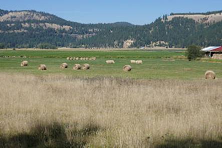 . In a short while ID97 ended and merged into
ID3 and the traffic increased noticeably.
This is probably because both ID97 and ID3 pulled traffic from I90 and
fed into ID3 at this point.
. In a short while ID97 ended and merged into
ID3 and the traffic increased noticeably.
This is probably because both ID97 and ID3 pulled traffic from I90 and
fed into ID3 at this point.
Then
there was a 3-mile descent on another reasonably good road and I cruised down
on the descent at about 30 mph. Then it
was flat the rest of the way to St. Maries where I arrived at 2:30 pm.
I
had initially planned to camp just outside the town but decided a motel would
let me take better care of my sore throat.
There was also a bridge into town that was under construction with a
one-lane crossing. This would have made
camping more difficult with inconvenient access to town.
In
town I found the Pines Motel which was the only motel and got a room for $75
but it was on the second floor. At first
I was going to muscle the loaded bike up to the second floor but thought better
of it and carried the rear panniers and duffel bag up to my room and then the
bike with the 2 front panniers.
After
cleaning up I walked a block or so up town to My Kitchen which had a spaghetti
special for $10 that was decent and a lot of food along with a soup option that
I took advantage of. I felt better after
that. Then I stopped at a convenience
store and got 2 soup noodles in a cup that just required adding hot water. My room has a microwave so I got that to help
with treating my sore throat.
Day 3: Thu, Sep 06, 2018 - St. Maries, ID to Deary,
ID [56.5, 6:30, 8.7 mph, +3,438', -2,730']
I
slept okay. My sore throat was gone but
I had a runny nose. I just kept some
tissue by my bed and took care of business when I had to. After I woke up my runny nose was pretty much
gone but I was stuffed up. Still this
was turning out better than I had expected.
I
had breakfast at a small cafe next door - 2 large pancakes and a side of
ham. It was a pretty good breakfast.
I
left town at 8:30, backtracking through town until I got back to ID3. Almost immediately there was a fairly steep
climb of 270 feet followed by a short descent and then the climbing resumed
with another 600-foot climb. This route
was labeled the White Pine Scenic Byway.
It was fine but not what I would consider a scenic byway but I guess
everything has to be labeled so it attracts tourists.
After
some up and downs there was a 430-foot descent and then a gradual uphill. After 15 miles, ID3 split left and I took ID6
right. Both ways would eventually get me
to Deary but ID6 was considered a better cycling route and it also offered a
couple of alternative routes.
Six
miles later I came into Enida, a small town where I was hoping I might find a
small store but instead I found a small eatery.
So I stopped and had a burger. I
was also considering whether rerouting to Potlatch to Moscow to Lewiston might
be better because there were more services.
However, there wasn’t much in Potlatch and it was another 20 miles to
Moscow which was more than I wanted to bite off for the day
So
I continued on my route to Deary via ID6.
However, there was a big hill in the way and I had to climb 700 feet on
what was becoming a very warm day, with a high expected in the upper 80s, too
high for my taste. The good thing was
this climb was a twisty climb which alternately offered shade and relief from
the sun.
This
was followed by a descent which gave all of the altitude back on a similar
twisty descent that was great fun flying around corners at 30+ mph. This eventually flattened out as I approached
Harvard where I needed to make some decision about my destination for the
day. There was an RV Park 2 miles
outside Harvard that I considered and there was a small eatery in Harvard. However, I had only covered 35 miles and it
was only 2:30 pm. Stopping at this point
would have made tomorrow’s route harder but, on the other hand, there was no
motel or campground in Deary so I would have to find some place to camp in
Deary.
In
the end I pushed on to Deary after stopping in Harvard for a cold drink. At an intersection I took ID9 to Deary and
immediately had a 400-foot climb as my reward.
The rest of the way was rolling into town with ID9 ending and ID8 taking
me the short distance into Deary, population 506. I made my usual one pass through town to see
what services were offered.
There
was a bakery and a food store. I stopped
at the food store for a cold drink. As I
was drinking outside the store I saw what looked like a town park across the
street that I hoped was my camping spot.
When I rode across the street to the bakery to check it out there was a
police officer exiting the bakery so I inquired about camping and he didn’t see
any problem.
The
bakery closed at 5 pm and it was almost that time so I ordered a pepperoni
pizza for take-out. It was a 12 inch
that was more than I needed but I took care of it.
A
little later I set up camp on a nice, flat piece of lawn. There was also a restroom where I was able to
clean up. However, I found a sprinkler
head so the question was whether I would get wet if the sprinklers came on
overnight. In any event, the choice to
push on to Deary looked like it was working out great.
Even
better, later I fired up my PC to record my day’s trip. Since I lost the ability to boot up to Linux
on this PC I had started using Google Docs to write my notes. I wasn’t sure whether this was going to work
when I didn’t have WiFi access but when I started up my chrome browser and went
to the Google Docs tab it showed that it was working offline. So the next time I had Internet access Google
Docs would sync up with the official document.
This was working out way better than I had expected.
This
turned out to be a good day. My choice
to push on to Deary worked out great and Google Docs was just fine too. Even my trip computer worked flawlessly
today.
Day 4: Fri, Sep 07, 2018 - Deary, ID to Lewiston,
ID [47.3, 4:04, 11.6 mph, +842', -2,712']
With
my runny nose I didn’t actual sleep until after midnight and then sleeping was
okay. The big news was I dodged the sprinkler
assault - maybe this wasn’t the day for sprinkling. But I wasn’t totally confident until I was
packed up and out of the park.
I
was at the bakery next door at 7 am when they opened up. I had a tasty breakfast burrito and a bear
claw along with coffee.
I
left town just before 8 on what promised to be an easy day. It was just a little over 40 miles to
Lewiston and all downhill except for a little climbing just outside of
town. Overall, I lost about 2,000 feet
of elevation including a 4-mile stretch of 7% downhill.
There
were 3 log trucks in the first few miles, one coming and two going and there
was no shoulder. The log trucks were a
fixture throughout the day.
Today’s
scenery was much different than the previous days. At first there were very large, hilly wheat
fields that had been harvested with patterns in the field according to the
passes of the harvester. Then there was
the big 4-mile 7% descent to the town of Kendrick in the Kendrick-Juliatta Valley.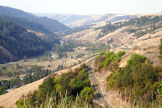 It was a tug of war between taking time to
admire the scenery and flying down the hill.
There were large brown/yellow hills on both sides.
It was a tug of war between taking time to
admire the scenery and flying down the hill.
There were large brown/yellow hills on both sides.
Kendrick
was a town of 300 that had a lot more services than one would expect in a town
of this size. I stopped at a grocery
store for some milk for my cereal breakfast.
There were no small milk containers so I made do with a vanilla protein
shake - just what I needed to power me down the hills. There was a nice park right across from the
store where I enjoyed my second breakfast.
The
scenery was great the rest of the way.
After 31 miles ID3 ended and merged into US12 that I took to
Lewiston. Originally I wasn’t going to
go to Lewiston but I decided a rest day was probably sensible, particularly
since the next day’s trip was 70 miles with a mile of climbing.
When
I got to the outskirts of town I had to decide where I wanted to stay. There were several motels on the outskirts
but they weren’t near many eating facilities.
I found an Inn America that was just across the Clearwater River that looked
like a good location. I called and was
quoted a price of $172 and asking for an AARP discount didn’t appear to work.
The
motel was easy to get to and when I checked in I asked again about an AARP
discount and this time I got a 10% discount.
I also got a room on the first floor although I saw later that there was
an elevator so a non-first floor room would probably have been okay.
After
cleaning up I walked to a fairly nearby Mexican restaurant for a decent
meal. At 3 pm, I was the only customer
at that time.
Then
I learned the motel had a guest laundry just a couple doors down from my
room. I didn’t really have to do laundry
but I figured I might as well since it was so conveniently located. After all, what could go wrong?
As
it turns out, everything. First, the
soap dispenser vending machine ate my $2 and let the soap hang on the lip of
the dispenser. So I had to get the front
desk to open the machine to get my soap.
That was the easy part. Next I
tried to deposit $1.50 in quarters and the washer took two of them and then
balked. Again I had to get the front
desk to take a look. A woman jabbed with
a paper clip and appeared to get the money unstuck. But when she deposited the money again the
washer had cleared out my settings. I
wanted to use cold water for my more delicate fabrics and we couldn’t change
that. We tried everything to reset the
machine with no success. Finally, I
turned off the hot water hose and that looked like it worked. But when I checked later it was hosed and it
was flashing “No h2o”.
So
in exasperation, I got the front desk to refund my soap and washer money and I
just rinsed everything in my room’s wash tub.
Then I stuck the wet clothes in the dryer which actually worked. Such an ordeal for what should have been a
convenient way to do my wash. I was
sorry there was a guest laundry.
Other
than for the laundry fiasco, it was a great day. It is hard to complain about a day that is
mostly downhill with great scenery.
Day 5: Sat, Sep 08, 2018 - Lewiston, ID
I
slept fitfully for the first half of the night but then I slept well and didn’t
wake until 7 am which is a late sleep in for me. The motel had a continental breakfast which
was fine.
Later,
I decide to walk downtown to check out a coffee shop and the city library. It was a bit of a hike, about a mile, but a
nice walk. As I neared downtown around
9:30 there were folks setting up along the street. This was Lewiston Roundup Rodeo week with a
10:00 parade. As luck would have it the
coffee shop I stopped at was upstairs where I had a good view of the
parade. Of course, the best part was all
the cowgirls riding horses. The interesting part was the pooper scoopers
periodically following the parade to take care of horses that weren’t potty
trained.
The interesting part was the pooper scoopers
periodically following the parade to take care of horses that weren’t potty
trained.
After
the parade I walked to the Lewis & Clark Information Center which was at
the confluence of the Snake and Clearwater rivers, not far from where Lewis
& Clark camped. Then I stopped at
the library on my walk back. There was
an Albertson grocery store a couple blocks from the motel and a Subway that I
visited. Then I retired to my room for
the rest of the day.
One
bit of good news is that the weather is cooling off a bit. Today was about 10 degrees cooler than
yesterday and the high tomorrow was projected to be 81F and then highs in the
70s the rest of the week.
Day 6: Sun, Sep 09, 2018 - Lewiston, ID to
Grangeville, ID [76.1, 8:35, 8.9 mph, +4,309', -1,760']
The
continental breakfast didn’t start until 7 am on the weekends. When I went down just before 7 a number of
folks had beat me to the breakfast. I
had a waffle, biscuits and gravy, and a bowl of cereal. Today was expected to
be a hard day so I wanted to get off to a good start.
I
left just before 8 and retraced my route back across the bridge. Then I picked up the frontage road until it
ended back on US12 East. I rode US12
back to the junction with US95. Along
the way I saw a bike path along the road that I didn’t know about. It would
have avoided some miles on US12 but US12 had a wide shoulder and traffic was
relatively light on a Sunday morning.
After
9 miles, I picked up US95 south. US95
generally had a wide shoulder but it was sometimes a little rough. More importantly, it had rumble strips in
places and when there was a guard rail it made the shoulder often useless for
riding.
One
good thing about the day’s route was there were several small towns along the
way where I could get a cold drink. At
Lapwai, I stopped at a grocery store with a deli for a ham and egg sandwich. I didn’t really need food yet after my big
breakfast but I decided it was better to take advantage of food while I could.
The
scenery was nice, first along US12 and then before the real climbing started on
US95. There were several large wheat
fields on the side of big hills that had nifty patterns from the harvesting
passes.
I
stopped for a cold drink at a restaurant along the road about midway between
Lapwai and Culdesac, which was at mile 23.
Shortly after Culdesac the climbing started and gradually got steeper
over the next 10 miles. I climbed at 6,
5, and then 4 mph over this stretch.
There wasn’t much to do other than keep pedaling away as I gained 3,100
feet of altitude.
At
mile 36 and 1:45 pm I crested the climb.
This was the halfway point for the day in terms of mileage but not in
terms of effort. The rest of the way was
a little downhill with some occasional moderate climbing.
Just
at the top of the crest there was a sign for a Rest Area. I took the turnoff hoping to get some water to
fill 2 of my water bottles that were empty.
I did that and also got a cold drink since there was a service station
that was part of the rest stop.
I
made good time the rest of the way. I
made a final stop at Cottonwood that was 15 miles from Grangeville. The rest of the way was mostly flat and there
was some headwind as the road turned eastward as it approached Grangeville.
I
reached Grangeville at 5:30, a tired puppy after a long day. I was in no mood for camping at that point so
I headed downtown where I knew there was a motel and figured it would be
cheaper than the 2 motels along US95. I
got a room for $65 that was the fall rate but not as cheap as I thought it
would be.
After
cleaning up I walked a block back to the main street and found a pizza joint
where I had a medium pepperoni pizza. I
finished all but 2 slices which I took back to my room for desert.
A
long and hard day, the hardest of the trip so far.
Day 7: Mon, Sep 10, 2018 - Grangeville, ID to
Riggins, ID [56.8, 5:54, 9.6 mph, +2,188', -3,616']
I
slept pretty well and should have after a hard day. I woke up to a novel feeling - I could hear
out of both my ears, with neither being clogged up. I took that as a good sign but by the middle
of the day they were clogged up again.
I
walked to the restaurant next to the pizza place where I ate last night for
breakfast, recommended by the motel owner.
I had the pancake combo with a piece of ham that was about twice as big
as you usually get.
I
headed out just after 8 am. I expected a
fairly easy day on the way to Riggins, 46 miles away. There was an early big climb but then there
was an 8-mile, 2,750-foot descent and then just a slightly uphill route the
rest of the way to Riggins.
Starting
out there was a view of the Camas prairie for several miles until the steep
2-mile ascent took me to the top of White Bird Hill. At the top there was a fabulous view of the
Salmon River Canyon below that I wasn’t prepared for. I stopped several times along the 8-mile
descent to admire the view and to take photos.
At
the bottom I stopped at the small town of White Bird. I stopped at a store just off the road for
milk for my second breakfast but it only had a few cold drinks. Instead I had to descend the short hill down
to the town where I got milk and cereal at a small store. After eating at the park across the street I
climbed the steep but short hill back to US95.
As
I started riding again I was passed by another touring cyclist. He stopped shortly to check his map and we
talked a bit. He was riding the
Transamerica route starting from Virginia and had less than 2 weeks to go. I was surprised to learn he was riding the
Transamerica since I had no idea it came through this part of Idaho. But then I realized US95 would take him into
Oregon whereas my route split off from US95 at New Meadows and took ID55 into
Boise.
This
guy was half my age, carried half the amount of gear, was in better shape at
this point in his tour, and was quickly out of sight. The rest of the way to
Riggins was one continuous scenic sight as it followed the Lower Salmon River
through the canyon. The day turned out
to offer great scenery all day.
Just
before reaching Riggins I saw a side road labeled Timezone Road and that
reminded me that the upper half of Idaho was Pacific time and the lower half
was Mountain time. This was where the
time zone changed.
As
I pulled into Riggins shortly after 2 pm, I rode through town looking for a
campground. There were several RV Parks but
they looked like they were strictly for RV vehicles. That was a total surprise since Riggins
purpose in life was to provide river rafting.
After I reached the other end of town I doubled back and stopped at the
library where I met the Transamerica cyclist again. He had found a place at the end of town where
he was able to just throw his tent up.
I
turned around and headed toward his find but checked places again. I stopped at the RV Park that I visited
earlier that looked like it didn’t offer camping and talked with the
owner. He offered other suggestions
including a BLM campground on the other side of the river. He said it was about a half mile but it
turned out to be a mile. But it was free
and had outhouses and it had a river where I was able to dunk myself to clean
up.
I
debated eating from my food supply but elected to cycle back to town and had a
good chicken sandwich. Then I returned
to my campsite and settled in for the night.
A
much easier day than yesterday and the best scenery of the trip so far.
Day 8: Tue, Sep 11, 2018 - Riggins, ID to McCall,
ID [50.4, 7:17, 6.9 mph, +3,752', -579']
I
was packed up and back at the same restaurant as last night for breakfast. It was almost 2 miles from campground to
restaurant. I had 2 very large pancakes
and ham. It was a good breakfast.
The
weather was overcast which was a change.
A couple of times the sun tried to peek through but the clouds won most
of the day and helped keep the ride cool.
I
was on the road by 8:30. It was only
about 50 miles to McCall but most of it was climbing. The first 24 miles climbed 2,000 feet. Then there was a 10-mile level area. Then the final 12 miles climbed about 1,200
feet.
Last
night when riding back from the restaurant I had a pain in my upper right thigh
near the knee cap. I’ve never had that
before but I guessed it was tendonitis.
This morning I had the pain again when I hit the road. It was a mild pain that worried me if riding
was going to make it worse. So I started
the day in easy gears trying to make sure I warmed up properly.
Today’s
scenery didn’t challenge yesterday’s.
The route followed the Little Salmon River upstream and the river wasn’t
the presence that the Lower Salmon River was yesterday. Also the hills were not as imposing and they
were covered with evergreens.
After
about 12 miles I stopped at an RV Park that had a camp store. They didn’t have regular milk but did have
chocolate milk so I used that with my cereal and it was okay. I didn’t really need another breakfast this
soon but it looked like it would be some time before anything else was
available.
The
shoulders on the road today were somewhat of a disappointment. Much of the road surface was covered with
chip seal which is not the smoothest surface.
Worse, for the shoulders they tended to spray the chip seal somewhat
unevenly under the theory that the shoulder wasn’t that important but this made
the shoulder somewhat uncomfortable for cycling. Then near the end of the long first climb the
shoulder was uniformly covered with chip seal like the main lane and this made
shoulder riding more comfortable.
However, the cost was they made the shoulder narrower, about 18 inches
wide. With a lot of big trucks passing
through it was hard to stay on the shoulder without falling off into the loose
gravel, which I did a couple of times and nearly dumped the bike.
After
37 miles I reached the flat part of the route.
The scenery opened up with some wetlands and then ranches with grazing
cattle.
At
2:30 I stopped in New Meadows at the junction of US93 and ID55 for a bite to
eat. When I left I left US95 behind and
took ID55 9 miles to McCall. Soon there
were signs of road construction the rest of the way. A good part of the road was steep and it was
hard riding. Worse, the shoulder was
very variable, sometimes nonexistent and other times cracked up and difficult
to ride.
The
best thing was there was a one lane road ahead.
This had the effect of grouping all of the oncoming traffic
together. When I saw the oncoming traffic
I just stopped on the shoulder to make it easier and safer for everyone to
pass. Then when I got to the one lane
section, our traffic got grouped together.
Of course I couldn’t keep up with the group so I just let the group pass
before getting back on the road.
This
stretch of road was very difficult. I
had to stop a number of times to rest and I usually don’t have to rest often
when climbing. I was actually half hoping they wouldn’t let me ride through the
one lane section and would force me to ride across on a pilot vehicle but the
one lane section wasn’t very long. At
the steepest part several of the construction guys were laughing that someone
would ride this stretch on a loaded bicycle.
I
kept plugging away watching out for traffic and finally reached the top and
then coasted into McCall around 5 pm.
Then I pulled out my phone and did a google maps search for motels and
found one that looked attractive on 3rd street not too far from the lake. When I got there it was full but there was a
Scandinavia Motel across the street and I got a room for $79 which wasn’t too
bad in a resort town although this was likely an offseason rate.
There
was a Subway nearby which took care of dinner for me.
A
hard day with almost no descending. My
bad leg didn’t hurt at all on the hardest climb so I didn’t know what to make
about that.
Day 9: Wed, Sep 12, 2018 - McCall, ID to Horseshoe
Bend, ID [83.5, 7:49, 10.7 mph, +1,291', -3,576']
I
slept well and when I got up I felt fine.
I had thought with my leg problem and the hard day that maybe I would
need to take a rest day. I also thought
McCall would be an interesting place to take a day off. Then I checked the weather forecast and saw
rain was forecast for tomorrow afternoon.
So I decided since I felt good that it would be better to ride today,
hopefully make Horseshoe Bend, and then need only the following morning to get
into Boise and avoid the rain.
The
nearby food mart also had a little cafe inside, Old Town Station Café, so I
walked there for breakfast. I had a
pancake, eggs, and bacon. This place had
a limited menu so I could only get a single pancake but it was a large
one. Since this wasn’t quite as filling
as I wanted I grabbed a ham and egg sandwich on my way out.
It
was a chilly morning, barely above freezing, and projected to get only in the
low 60s in the afternoon. I put on a
long sleeve jersey with a short sleeve jersey and a light jacket along with my
rain gloves and that was good to get started when I left at 8:30.
Traffic
was fairly heavy leaving town on ID55 with a so-so shoulder but not really a
problem. After 22 miles there was one
steep but short climb but most of the way was downhill, gradually for the first
40 miles and then dropping 2,000 feet over the next 20 miles, and then almost
level for the last 20 miles into Horseshoe Bend.
The
scenery was a big valley with surrounding forested hills. It was overcast so things looked a bit
dreary.
After
29 miles I rolled into Cascade and had a tasty smoked turkey wrap and a cold
drink.
Leaving
Cascade, it felt chillier than before and I put my light jacket on again. The road continued straight with a decent
shoulder. At the end of the valley, the
road dropped through a canyon as it followed the Payette River downstream the
rest of the way and was very scenic.
There was little to no shoulder on a winding road so you had to be alert
to traffic approaching from the rear and particularly with approaching curves
but it wasn’t a big problem. But I
understand this road can have a lot of traffic so it might be a different story
on the weekend with weekend traffic.
What
did become a problem though was my leg again.
It was fine all morning and then it started acting up again in the
afternoon. It was a good thing that I
could coast much of the way because the pain became a problem, even after I
took an Advil.
When
I neared the 60-mile mark just north of Banks there were 4 Forest Service
Campgrounds along the road. None of them
had water and weren’t near any services so I passed in hopes of reaching
Horseshoe Bend. Just after Banks I
stopped along the road to take care of business on the side of a hill. Just a little walking must have done the
trick because when I got back on the bike I was pain free. That was good because the closer I got to
Horseshoe Bend the more pedaling I had to do and that would have been a drag
with my bum leg.
I
rolled into Horseshoe Bend at 5:30 and promptly stopped at a food mart and
grabbed a sandwich and drink. There were
no motels or campgrounds in town so I had to find some place to throw up a
tent. Just past the food mart there was
a town park and that looked like the best option on my pass through this town
of 707. So I headed back to the town
park where there was also a city hall building.
I would have asked for camping permission but city hall was closed and I
didn’t see a police department around.
So
I hung around the park until 7:30, just before dark, and pitched my tent in the
most unobtrusive place and settled in for the night. Then around 9 pm a police
person rousted me out of the tent. He
gave me a bit of a hard time about camping in the town park saying camping
wasn’t allowed in town parks in Idaho although I noted I had been allowed to
camp in the town park in Deary. In the
end he admitted he couldn’t realistically expect me to pack up and leave at
night on a bicycle.
Day 10: Thu, Sep 13, 2018 - Horseshoe Bend, ID to
Boise, ID [30.1, 3:37, 8.3 mph, +1,826', -1,883']
I
didn’t sleep very well. In the morning I
packed up and road back up the hill a short way to a food mart that had a
Subway. I had a foot-long ham, egg, and
cheese sandwich. It was basically an
omelet on a foot-long sandwich. I had
never eaten breakfast at a Subway. The
“omelet” was cooked as I waited. It was
pretty good.
When
I left the cafe/bar on the other side of the street that I had hoped would be
open for breakfast was now open so it must have opened at 8 am.
I
left town about 8:30. I was only 23
miles from Boise but there was an imposing 1600-foot hill in the way. Worse my leg was acting up again. It wasn’t bad but I could feel it and worried
how bad it might get on a big climb. As
a precaution I took 2 Advils and never had a problem on the 6-mile climb.
Yesterday,
a local had suggested doing the climb on old 55 to avoid the traffic. I considered that but decided to use the
regular road. I wasn’t sure if the old
road might be steeper and it would not have been a good spot to try to
hitchhike if I needed to. And when I
looked at the route on Maps.ME it looked a little convoluted.
The
scenery was outstanding. I had worried
that my leg would be bad enough that I would have to hitch a ride and I would
have been sorely disappointed. The great
thing about riding was I could stop and check the view whenever I wanted and I
did that a lot on the way up.
At
the top of the Spring Valley Summit at 4,242 feet I stopped for my second
breakfast which I had earned. The
descent was not as scenic as the climb so I turned the bike loose. The shoulder was great for both the climb and
the descent. I managed to hit 46 mph on
the descent. Normally, at that speed I
would have wanted to be in the driving lane but the shoulder was good enough
for that speed which is unusual.
At
the bottom I stopped for a cold drink and then took Hill Dr east for several
miles until I picked up 21st street to my niece’s house. As expected everyone was working or in school
so I rode to a nearby coffee shop to kill time.
I
rode back to the house at 4 pm and Julia was home along with the kids. I spent the rest of the day getting
acclimated to a family running around the house and did a load of laundry.
Day 11: Fri, Sep 14, 2018 - Boise, ID
I
slept really well and didn’t get up until almost 8 am. Almost everybody was already gone to work or
to school. I chose to walk to Big City
Coffee and Café, a little over a mile away, that I had been to on a previous
ride through Boise. When I got there
around 10 am I was shocked to find it packed and a line almost to the
door. I was undecided what to do and
hung around for a few minutes. Then I
found a round table with only one other person sitting so I sat down since table
sharing at this place was common.
I
ordered the oatmeal and a pumpkin muffin.
Both were very good and too much food since the muffin was gigantic. I
spent a couple of hours at the place and a couple tables were finally freeing
up. I spent the time planning the next
phase of my tour, from Boise east to Soda Springs. I mainly researched what
motels and campgrounds were available along the way.
Finally,
I left and walked back home, stopping at an Albertsons for a few grocery
items. Then I cleaned my bike chain and
pumped up the tires.
Later,
we had pizza for dinner and then the crew went off to a high school football
game that turned out to be a blow out. I
chose to stay home and make sure everything was ready for my morning departure.
![]()

![]()
Copyright
Denis Kertz, 2018. All rights reserved.